Starting from this version user registration is optional: you can use BattleTac as guest to try it out or to track assets on the field. You need to register a user only when you want to upload your profile image.
Another news is that BattleTac is now translated to French, Hungarian, Italian, Portuguese, Spanish and Russian! If you feel that translation to your native language is the main thing what is missing from BattleTac, contact us!
There are also some usability improvements and a lot of bugfixes in this version. If you experience any problem, please send an issue report to us: you can send it from the support menu of the app, or using our website!
2013/12/10
2013/10/17
How to use Message Templates
We recently introduced message templates to BattleTac. This feature converts the painful chat system to a really effective communication platform. Here's how it works:

There are 2 template types:
Protip: You can create auto-send templates which are also part of a sentence: These will end the sentence and send it immediately. One example can be " minutes." , which - when you create it - makes it easy to enter a message like "Action in 5 minutes." (Where only the number 5 will be entered directly)

There are 2 template types:
- Auto-send templates are basic radio procedure words like "Roger.", "Positive." or "Radio Check.". When you select one, BattleTac sends it immediately. Auto-send templates end with a dot.
- Building block templates are words or expressions you use regularly during radio communication, e.g. "Action in " or "Get back to ". These templates are meaningful only as part of a sentence. They will be inserted into the message at the position of the cursor so you can continue writing the message.
Protip: You can create auto-send templates which are also part of a sentence: These will end the sentence and send it immediately. One example can be " minutes." , which - when you create it - makes it easy to enter a message like "Action in 5 minutes." (Where only the number 5 will be entered directly)
2013/10/10
Custom Maps in BattleTac
There is no GPS tracking without quality maps. Detailed satellite imagery of the field may be good enough: BattleTac shows you Google satellite as the default map.


If you have a precise drawn map of a field, you can upload it to our site and we will publish it to every BattleTac user. But you have to align the map to the GPS coordinates before uploading! A simple .jpg image is not enough: if we want to track GPS positions on it, we must know the exact position of your map on the world map. So you have to process your map using MSR MapCruncher.
MapCruncher is simple tool created by Microsoft Research. You can download it from here. You can watch a 5 minute intro video about it here. To learn more about the publishing process, read our documentation. It shouldn't take more than 10 minutes to convert your map!
As always, you can get help on the support forum!
If we have a custom map of a field, it will be displayed to every user automatically. You do not need to do anything, just use BattleTac and enjoy the map! The custom map is displayed over the base map so it is possible to upload a transparent map and get similar results as Google Hybrid:
Please note that there is a setting, 'Custom Maps': you can save a small amount of network traffic if you turn this feature off. Do this only if you are sure we don't have a custom map of the field or if you do not want to use the available map.
But there is more: You can create your own map and publish it to other players. A custom map is far more usable than the best satellite imagery: it contains a lot more important info and a lot less unimportant detail, as seen on this example:


If you have a precise drawn map of a field, you can upload it to our site and we will publish it to every BattleTac user. But you have to align the map to the GPS coordinates before uploading! A simple .jpg image is not enough: if we want to track GPS positions on it, we must know the exact position of your map on the world map. So you have to process your map using MSR MapCruncher.
MapCruncher is simple tool created by Microsoft Research. You can download it from here. You can watch a 5 minute intro video about it here. To learn more about the publishing process, read our documentation. It shouldn't take more than 10 minutes to convert your map!
As always, you can get help on the support forum!
If we have a custom map of a field, it will be displayed to every user automatically. You do not need to do anything, just use BattleTac and enjoy the map! The custom map is displayed over the base map so it is possible to upload a transparent map and get similar results as Google Hybrid:
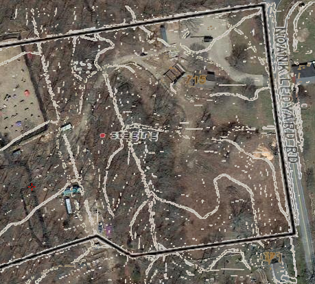 |
| Map of Fields of Fire mystic, ct, USA (Created by Andrew Wawrzynowicz) |
Please note that there is a setting, 'Custom Maps': you can save a small amount of network traffic if you turn this feature off. Do this only if you are sure we don't have a custom map of the field or if you do not want to use the available map.
2013/07/20
Heads Up Display in version 1.3.0!
Check out version 1.3.0, it is available on both iOS and Android! We have implemented the HUD which was the most required feature in our recent feature poll.
We have designed the HUD to be usable and battery-friendly, that's why it doesn't use the device camera. (read more)
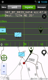
It contains a logarithmic scale to measure the distance and a compass display. If there is space available under the HUD, the map is also displayed.
On Android you can switch the HUD on/off using the back button, on iOS you have to use the menu.
Please note that the HUD needs accurate compass and location to work correctly! We have found during the tests that some devices have very inaccurate compass. BattleTac tries to figure out the compass accuracy and report if it is bad, but it is sometimes not possible. You can play with the compass using special compass apps to figure out its accuracy. Although there is room to further development in our app, the accuracy depends mainly on the hardware. If you have a quality phone (like an iPhone) and no hardware problems, it will work correctly.
Mount your phone on the gun or your arm and have a nice time with BattleTac!
2013/05/20
Service Outage
 Today, starting from 00:41 AM UTC we experienced an outage. At the time of this writing the service is up again. We apologize to everyone who was affected.
The cause of the issue was a hardware problem and that our service failed to migrate automatically to the new hardware.
We have identified some key improvements to our setup that we are implementing immediately.
2013/04/17
The state of Augmented Reality and its use in Airsoft
Google just shipped the first Glass units to developers: big step towards usable augmented reality applications!
We are experimenting with AR since 2010 when we integrated BattleTac with Layar.

Unfortunately the current AR technologies are nothing more than toys: I think this is the main cause of the failure of AR in the smartphone world.
The problem is that if we want to augment the visual reality then it is not enough to just display extra information on top of what the user sees, but we have to modify the visual content. So the display must be capable to modify the visual input on the whole field of view. Smartphones can augment the view of the camera, but your eyes are a lot better than the camera so you do not want to see through the camera.
That is where the goggles come in. Recon Instruments already ships HUD (Heads Up Display) goggles and now Google Glass is here. There is no difference, both goggles are just HUDs and we have to design the display system accordingly.
And the same is true when using your smartphone as a HUD: you want to use your eyes to see the reality and use the HUD to display extra information. What you do not need is the video stream from the camera.
So instead of a Layar-like camera-based display system we plan to implement a HUD which is not so fancy but more usable. Something like this:
Not displaying the camera image allows us to widen the field of view and display distance information in an easily readable way: You do not need to read numbers to know the approximate distance of a symbol. Additionally, this display works even if you use your phone in the normal, convenient position when the camera sees just the ground.
And we have to wait for the next generation of AR goggles in the hope that they will be real AR goggles so Augmented Reality will be really reality, not just a special effect:
We are experimenting with AR since 2010 when we integrated BattleTac with Layar.

Unfortunately the current AR technologies are nothing more than toys: I think this is the main cause of the failure of AR in the smartphone world.
The problem is that if we want to augment the visual reality then it is not enough to just display extra information on top of what the user sees, but we have to modify the visual content. So the display must be capable to modify the visual input on the whole field of view. Smartphones can augment the view of the camera, but your eyes are a lot better than the camera so you do not want to see through the camera.
That is where the goggles come in. Recon Instruments already ships HUD (Heads Up Display) goggles and now Google Glass is here. There is no difference, both goggles are just HUDs and we have to design the display system accordingly.
And the same is true when using your smartphone as a HUD: you want to use your eyes to see the reality and use the HUD to display extra information. What you do not need is the video stream from the camera.
So instead of a Layar-like camera-based display system we plan to implement a HUD which is not so fancy but more usable. Something like this:
 |
| Planned functionality |
Not displaying the camera image allows us to widen the field of view and display distance information in an easily readable way: You do not need to read numbers to know the approximate distance of a symbol. Additionally, this display works even if you use your phone in the normal, convenient position when the camera sees just the ground.
And we have to wait for the next generation of AR goggles in the hope that they will be real AR goggles so Augmented Reality will be really reality, not just a special effect:
2013/03/27
New feature: Status Page
 Just released v1.2.1 with a design facelift and the new App Status page.
The App Status page displays every essential information you need to check the health of the system:
If you have no network signal, then the Data Connection will display Offline. If the GPS accuracy is bad (worst than the one you have configured in settings) then it will be displayed using red. So if you don't see any red text then you are OK.
With the 'Sync now' button you can force the COP synchronization which means that the app will upload your current position and download the positions and messages from other units.
This COP synchronization happens automatically in every 30secs - 15mins according to what you have configured, but one way to conserve the battery is to set the position upload interval to a high value and report the position manually using the 'Sync now' button.
Note I: This update is available for the paid versions on both iOS and Android. The Lite versions will be updated shortly.
Note II: This version fixes the bug of 1.2.0 (released yesterday) on iOS which caused app to crash at startup on some devices.
2013/03/26
Bad iOS update
Today we have released a new version of the paid app on iOS which contains a bug and fails to start on some devices.
Unfortunately Apple gives us no way to get back to the older version so we have removed the app from the store temporarily and uploaded a bugfix version. Now we have to wait for Apple to validate and release it.
For those who have installed the update, we are very sorry but no workaround is available. Please use the lite version while you are waiting for the bugfix release.
Sorry for the inconvenience, this is definitely our fault.
2013/03/10
Improving GPS accuracy
A frequently asked question is: How can we improve the accuracy of the GPS?

First of all, you have to know that modern mobile operating systems like iOS and Android handle the GPS, the app just gets the location data from the device. So all apps are created equal in terms of GPS accuray and there is no way to improve it inside the app. Only you can do a little bit to improve the accuracy.
There are apps for monitoring the GPS of the device, they show you the number of visible satellites so you will be able to find a place where the GPS signal is better. These apps are not able to boost the GPS, they just give you information about the state of it. This looks professional, I suggest you donwload one of them and play with it, but you don't really need this for finding a place with better signal: just find a place where you can see the sky.
Yes, the most important thing is to see the sky. Do not cover the device while you are waiting for a GPS fix, and never expect good GPS signal inside buildings.
If you have network signal then AGPS can work. AGPS helps your device to find the first fix faster, because it will tell it where the satellites currently are so the location calculation will be easier. Having the first fix is always the hardest thing.
So the second thing you can do is finding a location where you have data connection.
If you have one location fix then it may start working on places where the GPS signal is not so good.
Note that at home you can get good accuracy indoors because your device uses wifi positioning, not the GPS. But this works only where a lot of wifi stations are near to you so definitely not on the airsoft site.
This means that you can track your location with your smartphone only outdoors.
Lastly, you have to know something about BattleTac: There is a setting: 'Position report interval' which you can change to a higher value (e.g.: 5 minutes) to save battery time, but if you do it, you may get worse GPS performance. This is because 5 mins pause is too much for the GPS, it will 'cold start' every time which is harder as I have said. So if your GPS signal is bad then I suggest you using the default value of this settings.

First of all, you have to know that modern mobile operating systems like iOS and Android handle the GPS, the app just gets the location data from the device. So all apps are created equal in terms of GPS accuray and there is no way to improve it inside the app. Only you can do a little bit to improve the accuracy.
There are apps for monitoring the GPS of the device, they show you the number of visible satellites so you will be able to find a place where the GPS signal is better. These apps are not able to boost the GPS, they just give you information about the state of it. This looks professional, I suggest you donwload one of them and play with it, but you don't really need this for finding a place with better signal: just find a place where you can see the sky.
Yes, the most important thing is to see the sky. Do not cover the device while you are waiting for a GPS fix, and never expect good GPS signal inside buildings.
If you have network signal then AGPS can work. AGPS helps your device to find the first fix faster, because it will tell it where the satellites currently are so the location calculation will be easier. Having the first fix is always the hardest thing.
So the second thing you can do is finding a location where you have data connection.
Note that at home you can get good accuracy indoors because your device uses wifi positioning, not the GPS. But this works only where a lot of wifi stations are near to you so definitely not on the airsoft site.
This means that you can track your location with your smartphone only outdoors.
Lastly, you have to know something about BattleTac: There is a setting: 'Position report interval' which you can change to a higher value (e.g.: 5 minutes) to save battery time, but if you do it, you may get worse GPS performance. This is because 5 mins pause is too much for the GPS, it will 'cold start' every time which is harder as I have said. So if your GPS signal is bad then I suggest you using the default value of this settings.
2013/03/04
1.1.0 is out with a lot of usability enhancements
We have focused on enhanced usability and better information display in this release. The new features are:


This new version is available in the Android Play Store, and it is on the way to the App Store too - we have to wait about 5 days for Apple to review it.
- Recon symbol is now available:
- If your reported position is older than 2 minutes, it will be flagged as 'anticipated' and displayed with a dashed corner according to Mil Std 2525A/APP-6A:
- If you have a destination, it's distance and direction is also displayed. The direction is displayed both with an 1-2 letter mark and in degrees.

- The POI and unit pages are more readable, the direction info is also included:

- If creating a poi or sending a message fails because of network outage, the system tries the communication again later. It tries again and again for a while before it gives up. If sending a message is not possible for 10 minutes then the message i deprecated anyway so it's OK to give up - we think.
- (Full version only): It is possible now to set the location update frequency to 1 minute. The default setting is 30 seconds but we recommend setting this to a higher value to save battery time.
This new version is available in the Android Play Store, and it is on the way to the App Store too - we have to wait about 5 days for Apple to review it.
Try out this and give us feedback on our new Facebook page!
2013/02/27
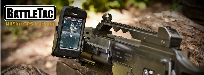
Rugged cases for your device
The device on our header image is an old iPhone 3GS in an OtterBox Defender case. This case is great, waterproof and durable, and costs about USD 50. (Check it out here)
There are tons of rugged cases available for mobile devices, but if you are on the Android side it may be better to choose a rugged device: They are here for a time now and new models are coming continously.
Resources:
There are tons of rugged cases available for mobile devices, but if you are on the Android side it may be better to choose a rugged device: They are here for a time now and new models are coming continously.
Resources:
- A list of iPhone cases on reviews.cnet.com
BattleTac blog started
We will share here BattleTac tips&tricks, feature announcements and general info about GPS, blue force tracking, rugged devices and other interesting topics related to BattleTac.
Feliratkozás:
Bejegyzések (Atom)