But there is more: You can create your own map and publish it to other players. A custom map is far more usable than the best satellite imagery: it contains a lot more important info and a lot less unimportant detail, as seen on this example:


If you have a precise drawn map of a field, you can upload it to our site and we will publish it to every BattleTac user. But you have to align the map to the GPS coordinates before uploading! A simple .jpg image is not enough: if we want to track GPS positions on it, we must know the exact position of your map on the world map. So you have to process your map using MSR MapCruncher.
MapCruncher is simple tool created by Microsoft Research. You can download it from here. You can watch a 5 minute intro video about it here. To learn more about the publishing process, read our documentation. It shouldn't take more than 10 minutes to convert your map!
As always, you can get help on the support forum!
If we have a custom map of a field, it will be displayed to every user automatically. You do not need to do anything, just use BattleTac and enjoy the map! The custom map is displayed over the base map so it is possible to upload a transparent map and get similar results as Google Hybrid:
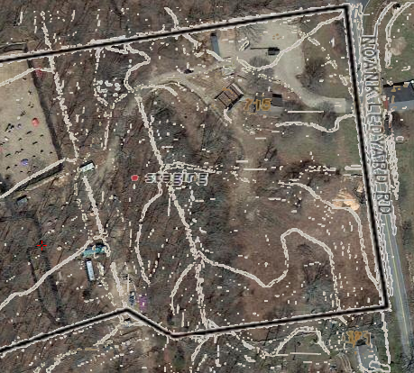 |
| Map of Fields of Fire mystic, ct, USA (Created by Andrew Wawrzynowicz) |
Please note that there is a setting, 'Custom Maps': you can save a small amount of network traffic if you turn this feature off. Do this only if you are sure we don't have a custom map of the field or if you do not want to use the available map.
Nincsenek megjegyzések:
Megjegyzés küldése